Exploration of the Caves in the Akumal-Tulum Area
Exploration of the Caves in the Akumal-Tulum Area
By Daniel Riordan
 |
|
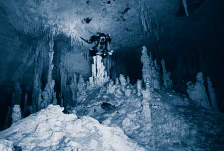
Photo by Daryl Silverstein.
|
Picture yourself diving in an unexplored cave. Suddenly, after checking out several dead-end leads, you squeeze through an area that does not look very promising. After making sure that the line is laid properly, you look in front of you. You are now in the middle of a subway-sized tunnel, with passages extending in several directions as far as your powerful light can cover. This is every explorer’s dream. Real exploration, however, has little in common with imaginary exploration; it requires hard work and preparation. It rarely entails showing up at a site and finding unexplored passage.
When discussing the exploration of cave systems in the Akumal-Tulum area of Mexico’s Yucatan Peninsula, several things deserve mention. The first is the history of exploration efforts in the area, an examination of which helps present-day explorers take advantage of information generated by their predecessors. The second is the need for familiarization with what is already known about area cave systems and their respective environments. The third is a consideration of the intricate logistics demanded by exploring caves in the jungle, logistics that demand careful planning. Lastly, no exploration would be successful without the human resources that help realize these logistics.
|
|
History
The history of exploration in the Akumal-Tulum area of
Mexico’s Yucatan Peninsula began in the late 1970s. Sheck
Exley, along with several others, did some exploration of the caves
in X-caret and Nonec. Also, there was some limited exploration of
the caves in the Xel-Ha lagoon by scientists (OW divers).
In 1982, in a beautiful swimming hole by the side of the road, fifteen kilometers from the village of Tulum, a group of open water divers from California decided to go for a dive in a crystal clear pond. The wind had been blowing strong and the boats were not going out. During the course of their dive, the group was surprised to see an enormous opening defining one side of what, to them, appeared as a circular pond. Their curiosity getting the best of them, they ventured a few feet inside this beautiful and enormous cavern. However, having read a few articles about the caves of Florida, and being aware of some of the potential hazards that they might face in an overhead environment, they decided to be “safe” and return another day with a line that they could follow inside this cavern. The next day they returned carrying two hundred and fifty feet of ski rope. This was the first line laid in this particular system. The name of the swimming hole: Cenote Carwash.
Cenote Carwash got its name from foreign campers, who in the mid-1970s used it for washing their vehicles, diving, hacking around and bathing. Taxi drivers from the nearby village of Tulum also had their cars washed there. Ironically enough, the US Deep Caving Team dove in Carwash in the very early 1980s and declared that there was no cave there. Today, Carwash (or, as the local owners call it, Aktun Ha, or “Water-filled Cave”) is one of the most popular cave systems in this area.
It was around this time that Jim Coke, a well-known cave explorer and cartographer, joined by explorers like Tom Young, Johanna DeGroot, Parker Turner, and Mike Madden, began the exploration of several cave systems like Carwash, Naharon, Temple of Doom, Mayan Blue and Sac Actun (in that order). These early efforts led to maps with a high degree of accuracy and detail. Coke’s maps are used as the measuring stick for hand drawn maps of water-filled caves.
In the late 1980s, Mike Madden had the privilege of being taken to one of the most beautiful cave systems in this area: Nohoch Nah Chich (Mayan for “Giant Birdhouse”). Cave diver Hilario Hiller had already visited this cave several times, although his exploration had been limited. With crystal clear water, no apparent flow, highly decorated passages, and an average depth of 30 feet (9 meters), Mike was like a kid in a candy store. Of his first dive in Nohoch, Madden recounts how, finding himself with no line left on his exploration reel, and going passage before him, he would have used his shoelaces to add more line, if he had had his boots on.
Wanting to explore Nohoch, Mike found himself facing serious logistical problems, as the main entrance to the cave system was located several miles in the jungle. During the 1990s, Mike organized several successful exploration projects that involved setting up base camps and transporting gear by horses to the outlying cenotes. For several years, Mike led his team in a number of successful projects; a team that, for a time, held the record for the longest underwater cave in the world. Another notable accomplishment took place in 1996, when Madden´s team established a physical connection to the Caribbean Sea. Mike also produced an artistic map, created by cartographer Eric Hutcheson.
In the neighboring Dos Ojos system, Buddy Quatlebaum led his own team of explorers. One of their goals was to connect Dos Ojos to Nohoch Nah Chich, but this elusive connection was never found. Buddy has led his team on several projects that have managed to exceed Nohoch’s overall size in terms of length of discovered passages. If there is more passage, there is no available data to prove it. Furthermore, and as a sign of what the future may have in store for Dos Ojos, there are several systems neighboring it that, if connected to it, one day will significantly expand its size. Today, a deeper section of Dos Ojos, with depths in excess of 300 feet (90 meters), has been the object of several expeditions, most of them organized by Buddy.
|
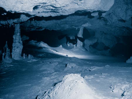
Photo by Sabine Schmittger
|
 |
|
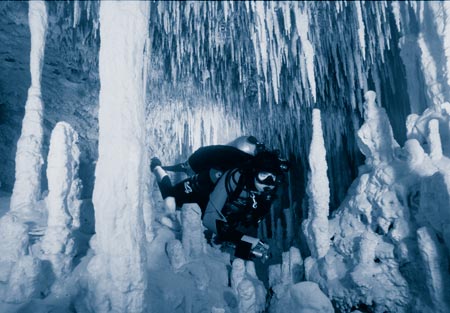
Photo by David Riordan
|
Kay and Gary Walten have also made significant contributions to exploration in this area, having explored several cave systems; Yax Chen is their biggest one. For this cave system, marked by multiple cenotes, they were faced with no land access to any of them, as these were all located in a vast area of mangroves. All their exploration began from the same opening, making the exploration of remote areas particularly challenging.
Grupo de Exploración Ox Bel Ha (GEO) focused on exploring a system called Ox Bel Ha, Mayan for “Three Paths of Water.” The name Ox Bel Ha refers to three diveable vents to the Caribbean Sea. Ox Bel Ha is located near the village of Tulum, in the Ejido Pino Suarez and the Ejido Tulum. With a limited budget, but well organized logistics, GEO managed to maximize the resources that were available to them. Exploration began in a cenote located deep in the jungle between the beaches of Tulum and Highway 307. The first base camp was set up in May 1998, giving up 38,000 feet (11,500 meters) of surveyed passages. Since that project, at least one major jungle project a year has been organized, each one lasting about two weeks. Between these, mini-projects have been conducted to less remote areas. Utilizing aerial photography and information generated during previous projects, GEO managed to explore and connect several surrounding systems. Ox Bel Ha is now the world’s longest underwater cave system with over 325,000 feet (98,000 meters) of discovered and mapped passages. Team members of GEO are: Bernd Birnbach, Steve Bogaerts, Fred Devos, Christophe Le Maillot, Sam Meacham, Bil Phillips, Daniel Riordan and Sabine Schnittger.
Several other explorers have been working on different projects in this area, and are working to extend the established systems, and to explore new ones.
Familiarization
Before venturing into new areas, it is important that one becomes
familiar with what is already known. This is especially true of
exploration in the Tulum-Akumal area. Before considering exploring
new terrain, local explorers will spend a great deal of time
getting acquainted with what is already known of the environment,
and will seek to determine whether a trend exists that will help
provide them with clues to addressing the challenges of
exploration. Aerial photographs, topographical maps, and
discussions with local community members, if considered carefully,
may enable an aspiring explorer to find clues to an enormous
puzzle. These clues, once confirmed by actual exploration, will
yield the exhilaration of finding oneself before a brand new
discovery: unexplored cave. In some ways, an explorer’s
relationship to a cave is personal. The more one studies it, the
more familiar and involved one becomes with it, the more a cave
reveals its secrets.
Logistics
Exploration in the Tulum-Akumal area usually involves complicated
logistics, as most cenotes are found deep in the jungle with little
or no road access. This requires getting the requisite exploration
equipment to a remote site in the jungle, and there set up a base
camp. Base camp logistics in this area can be very complicated and
are sometimes subject to the most unusual twists of fate. For
example, on the last Ox Bel Ha exploration project, two permanent
base camp horses decided that they did not care for the two hundred
pounds of food that was brought into camp for them. As the horses
were needed to ferry equipment to nearby cenotes, someone had to
walk one hour’s journey out of the jungle, cut the particular
type of grass to which the horses were accustomed, and then
transport it back to camp. As difficult as it may seem, it is
important that one try and plan for even such remote eventualities.
Logistical planning starts months before a project begins. Among
other things, logistics include: getting permission to dive during
the period planned, machete cutting of horse trails to base camp
(on more than one occasion this has included unplanned trips to the
doctor for stitches), hiring transportation for horses, hiring
people to assist at camp, planning a menu, servicing of the
compressor and the generator, creating schedules and goals for each
phase of exploration, accounting of finances, setting up channels
of communication, establishing emergency procedures, etc. The final
dive does not signify the end of a project, as dismantling and
stowing the base camp gear can take several days. Furthermore,
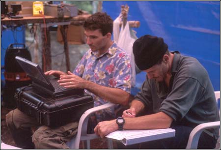
explorers have a responsibility to publish their discoveries,
efforts that may take several weeks.
Human Resources
Lastly, one cannot over-emphasize the value of human resources in
making exploration a success, from sponsors, to those who do most
of the physical labor. This is especially true when exploration
efforts involve remote sites in the Yucatan jungle. For example,
the people that help Grupo de Exploración Ox Bel Ha (GEO) with
manual labor and other surface logistics are usually locals that,
during the course of the project, become like family members.
Unbelievable people, they carry equipment, take care of horses,
cook, fill tanks, help divers get in and out of the water, and
carry out assorted other tasks. Their critical value to the success
of a project can be seen from the following example. One of the
items that cannot be carried on horseback is the compressor; two
people must attach sticks to it and actually walk it in. This is an
enormous challenge considering that this compressor must be carried
over uneven jungle terrain, for an excess of an hour, often under
hot and humid conditions. Such examples abound, with locals
carrying oxygen K bottles strapped to their forehead, and others
carrying four AL 80s for 45 minutes without resting. Without
GEO’s helpers, Santos and Celiano, and their families, GEO
would not have enjoyed the successes it has. The value of human
resources cannot be underestimated here; it makes or breaks
exploration.
Exploration can be very rewarding in the Tulum-Akumal area, but
it requires a lot of dedication. Organizing an exploration project
requires months of research and preparation. In the end, however,
the rewards are worth all the effort, as it brings us one step
closer to understanding the mysteries of the Mayan
underworld.
 |
|
Photo by Daryl Silverstein
|
