Hydrogeologic Setting
| Ground Water - Surface Water Exchange A View from Inside the Unconfined Karstified Floridan Aquifer with Implications for Ground Water Protection |
|||
|
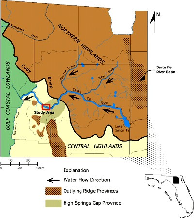
Florida Karst The phreatic cave systems in Florida are of particular hydrogeological interest because of the large volumes of water they transmit from upland recharge areas to spring discharge points on Florida's major rivers such as the Suwannee, the St. Johns, the Santa Fe, the Oklawaha, and the Withlacoochee. All of the first magnitude springs in Florida are the discharge points for major phreatic cave systems. Where the Floridan aquifer is confined by impermeable layers, recharge occurs through sinkholes and other discrete points that breach the confining layer and penetrate the limestones. Acidic waters dissolve conduits that become larger downgradient until they terminate at spring discharge points. Manatee spring on the Suwannee river near Chiefland, Florida is a perfect example. There, a conduit approximately 7 m in diameter extends for over 3 km from the spring that discharges 5.0 m3/s into the upland recharge area. Other examples include: Silver spring on the Oklawaha river near Ocala, Florida (22.8 m3/s discharge), Blue spring on the St. Johns river near Orange City, Florida (4.5 m3/s discharge), and Blue spring on the Withlacoochee river near Madison, Florida (3.2 m3/s discharge). Average discharges for the largest springs in Florida are provided by Lane (1986). On an even larger scale, dendritic cave systems form when conduits stemming from several discrete recharge points converge on a single spring. The Woodville karst plain in the central panhandle of Florida contains one of the most extensive dendritic cave systems ever documented. Wakulla spring with an average discharge of over 10.9 m3/s is the major discharge point for the entire Woodville karst plain which hydraulically connects Tallahassee, Florida with the Gulf of Mexico. Over 60 km of independent phreatic caves have been physically mapped in the region and have been connected by dye tracing. Conduits in the Woodville karst plain reach up to 30 m in diameter and trend at a depth of approximately 90 m. Active exploration is now being conducted that is adding over 2 km per month to the underground map of the Woodville karst plain. When the inevitable connections are made there, the Wakulla spring system will be the largest known phreatic cave system in the world. In order to appreciate the size of this particular cave system, consider that the discharge from just Wakulla spring could supply each person in Florida with more than 70 liters of fresh water per day based on a 1992 census of over 13 million residents. In regions where the confining layer is absent, precipitation infiltrates directly to the aquifer creating anastomosing cave systems. Typically in these regions, smaller conduits extend from beneath a karstified limestone surface and trend downgradient toward large conduits that discharge to rivers and streams. In many cases, however, where the limestone surface is dissected by streams or rivers, part or all of the river flow is diverted underground into the large conduits. Many rivers and streams in Florida such as the Santa Fe and Alapaha rivers are diverted underground immediately after they flow into regions where the Floridan aquifer is unconfined. Even after the rivers discharge back to the land surface, ground water and river water are continually exchanged because of the absence of a confining layer beneath the river bed. The Devil's Ear cave system studied during this investigation is a perfect example of an anastomosing cave system that both distributes and receives water from an overlying river. Permeabilities associated with these dissolved conduit systems far surpass that of the bedrock even though the limestone itself is highly transmissive. The conduit permeabilities thus present an overwhelming control on the regional ground water flow patterns. Rather it infiltrates directly or drains into sinkholes, water flows through small tubes that feed larger conduits and eventually discharges at springs. Cave maps provide an excellent picture of the ground water flow patterns, however, since cave-divers are restricted to conduits passable by humans, they represent only a small fraction of the interconnected tubes that dominate the permeability structure of the Floridan aquifer. The Santa Fe River Basin The Ocala Limestone, formerly the Ocala Group (Scott, 1992), Hawthorn Formation, and Alachua Formation are the three geologic units present in all or part of the Santa Fe river basin that are significant to this investigation. The Ocala Limestone, a thick sequence of highly permeable Eocene limestone beds, is the predominant geologic formation comprising the Floridan aquifer. Extensive karstification in the Ocala Limestone has created anisotropic conditions where permeability has increased by many orders of magnitude in dissolved conduits. The Hawthorn Formation is a 25 to 30 m thick Miocene sequence of phosphatic clays and dolomitic limestones that overlies the Ocala Limestone in the eastern Santa Fe river basin. Where present, the Hawthorn Formation effectively confines the Floridan aquifer. The Alachua Formation is a thin sequence of phosphatic sand and clay deposits thought to be erosional remnants of the Hawthorn Formation that exist as outlying hills and ridges in the western part of the Santa Fe river basin covering the Ocala Limestone (Williams et al., 1977). The Alachua Formation is ineffective at confining the Floridan aquifer (Hunn and Slack, 1983). Figure 3 adapted from White (1970) shows the location of the Devil's Ear cave system and the course of the Santa Fe river across the three physiographic provinces that merge within the Santa Fe river basin: the Northern Highlands, Central Highlands, and Gulf Coastal Lowlands. The basin is divided into two distinct zones, the eastern half lying in the Northern Highlands and the western half which is subdivided by the Central Highlands and Gulf Coastal Lowlands. The Santa Fe river originates in the Northern Highlands, a large flat plateau ranging in elevation between 50 and 60 m where the Floridan aquifer is confined by the Hawthorn Formation. Precipitation in the Northern Highlands drains to the Santa Fe river and it's tributaries (Hunn and Slack, 1983).
The Santa Fe river flows west across the Northern Highlands to the Cody Scarp, an extensively karstified transition zone between the confined and unconfined parts of the Floridan aquifer (Scott, 1991) where it disappears into O'leno sink. From O'leno sink, the river flows underground for over 5 km to its resurgence at the River Rise. From there, the river flows onto the lowland limestone plains of the Central Highlands and Gulf Coastal Lowlands where the Floridan aquifer is unconfined and precipitation infiltrates directly into the aquifer. Below the River Rise, the Santa Fe river is both a gaining and loosing stream. It receives considerable water from several springs, however, less noticeable are the frequent “sucks” where part of the flow is diverted underground for some distance (Ellins et al., 1991; Kincaid, 1994). Hisert (1994) conducted tracing experiments at O'leno State Park which demonstrated that, after disappearing into O'leno sink, the Santa Fe river flows at over 5 km/ day to its resurgence point at the River Rise. Hisert recorded the ground water tracer at 8 intermediate sinkholes between O'leno sink and the River Rise which are now known to be karst windows that intersect the underground flow path of the river. Furthermore, he found that over 40% of the resurgence at the River Rise is ground water that augmented the river flow. The Devil's Ear Cave System
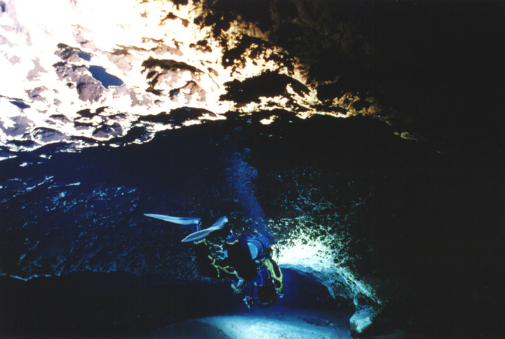
As shown on Figure 5, small tubes and conduits extend from the recharge area on the north side of the river to a larger conduit that parallels and, in places, directly underlies the river. Three springs (July, Devil's Eye, and Devil's Ear) discharge most of the water from the cave to the river. The combined discharge from these springs averages 8.5 m3/s (Wilson and Skiles, 1988). The main conduit in the cave system trends east-west for over 1,500 m upstream from the entrance at Devil's Ear spring. The depth of the conduits is relatively consistent at 33 m below the water surface in the river except where they rise to meet the Santa Fe river at the three principal springs. Three regions of the cave system shown on Figure 5 as A, B, and C, are the closest to the Santa Fe river. In these regions, dissolved joints in the limestone that are passable by divers proceed up to a depth of less than 3 m.
Water clarity in the conduits is typically clear but becomes turbid during higher stages of the river or after flood events. During periods of turbid water discharge at the three springs, cave-divers report that clear water enters the main passage from the northern conduits and mixes with turbid water from the southern conduits producing the turbid water discharge visible at the surface. Reverse flow, a common situation at many springs in Florida where spring discharge is reversed and river water flows into a cave system through the spring opening, has never been reported at the Devil's Ear cave system. The absence of reverse flow during high river stages reflects the unconfined condition of the Floridan aquifer and reveals that the aquifer is receiving direct recharge from the river. |