Problems of Groundwater and Surface Water Management: Part 2
Ecology:
Problems of Groundwater and Surface Water Management: Part 2
BY DR. TODD KINCAID
 |
|
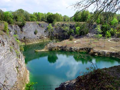
Florida
Limestone Quarry
|
Introduction
Part 1 of
this article (Kincaid, 2002) discussed the primary legislation
that drives groundwater and surface water protection efforts in the
U.S. at the state and federal levels. Though the programs have
contributed to a significant decrease in point sources of pollution
to both reservoirs, overall groundwater and surface water quality
continue to degrade, a fact which is particularly evident in
Florida Springs where increasing nutrient levels are causing
diminished water clarity and changes to the ecologic systems. Part
1 argued that one of the primary culprits here is the segregation
of legislative measures into separate programs, programs that are
slow to recognize the interactions between the two reservoirs and
the increasingly apparent fact that pollution to one can and will
lead to pollution to the other. The remainder of this article will
present some of the basic scientific principles that govern
groundwater and surface water interactions and discuss examples of
common pollution problems that confront the two reservoirs. Key
terms that are common to most technical discussions about
groundwater/surface water exchange are described and marked by
italic font in the text.
Scientific Overview
Hydrogeologic Cycle
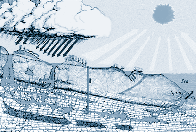
The hydrologic cycle (Figure 1) describes the pattern of continuous
water circulation through air, land, and sea that is always active
in our global environment. Precipitation that falls on the land
surface via rainfall or snow either runs off to streams, lakes, and
rivers or seeps into the ground and saturates underlying rocks and
soil. The saturated rocks and soil are described as aquifers and
the process of filling the aquifers is described as recharge. Once
the rocks are saturated, underground water (groundwater) flows
through interconnected pore spaces in the rocks to reemerge
(discharge) at the land surface at springs that feed streams,
lakes, rivers, or oceans. Eventually, all of the water in both the
groundwater and surface water reservoirs will flow to lakes,
reservoirs, or oceans where it will evaporate and move back into
the atmosphere to fall somewhere else as precipitation once
again.
 |
|
Figure 1. The
hydrologic cycle specific to karst regions demonstrating that water
is in constant motion on a path from the atmosphere from which it
falls as precipitation, to rivers and streams or groundwater, and
then to surface water reservoirs from which it evaporates back to
the atmosphere. The rate of motion, however, can be highly variable
particularly in the groundwater component of the cycle in karstic
regions.
|
Though all of the water on Earth is in constant motion, the rate of motion and therefore the age of the water since precipitation are highly variable. Precipitation that runs off directly into streams and rivers will travel very quickly downstream to reservoirs where it evaporates again. On the other hand, groundwater in deep aquifers may take tens of thousands of years or more to reach its point of discharge. It is therefore the rate of travel that gives rise to the significant difference between the science of groundwater and the science of surface water and, therefore, between the respective protection strategies. In turn, the rate of exchange between groundwater and surface water reservoirs is emerging as the most significant aspect of the two sciences and the most important variable that needs to be assessed if protection strategies are to be effective.
Truly understanding the hydrologic cycle and its implications is the most fundamental and important component of the hydrogeologic profession. At both local and regional scales, the hydrologic cycle defines a water budget for both groundwater and surface water reservoirs that must be defined and honored in order to ensure sustainable resource utilization. Additionally, the graphic representation of the hydrologic cycle should convey three important concepts to the non-professional.
- For all practical purposes, the quantity of water on Earth is constant; like matter and energy it is neither created nor destroyed.
- Water is in constant motion, traveling in a circular path between the atmosphere and surface water and groundwater reservoirs (though the rate of travel is highly variable).
- At the regional scale, the source of all the water that fills both groundwater and surface water reservoirs is rainfall that either recharges the aquifers or runs off over the land surface and collects in streams, rivers, and lakes that eventually drain to the sea.
Florida Hydrostratigraphy
Hydrostratigraphy is a term used to describe the layering and
relative permeability (hydraulic conductivity) of rocks and
sediments in the subsurface through which groundwater flows. Layers
of relatively higher permeability, especially if they are targeted
as water supply sources, are typically described as aquifers.
Layers of relatively lower permeability are typically described as
either confining layers, because they confine water to the aquifers
that they bound, or aquitards, because they transmit very little
water. By defining the hydrostratigraphy at several locations in a
basin, it becomes possible to map the distribution and thicknesses
of both aquifers and confining layers, which is the most important
aspect of aquifer vulnerability mapping.
There are three major units: the Floridan aquifer, the surficial aquifer, and the Hawthorne Formation confining unit that includes an intermediate aquifer system. The Floridan aquifer is the primary aquifer in Florida and one of the largest and most productive aquifers in the world. The Floridan aquifer underlies an area of approximately 100,000 square miles in southern Alabama, southeastern Georgia, southern South Carolina, and all of Florida. It is comprised primarily of Oligocene to Eocene age limestone rocks such as the Ocala, Suwannee, and St. Marks Formations that were deposited as submarine sediments and then elevated above sea level as a result of uplift of the Florida platform and sea level fluctuations. All of the major caves in Florida have developed in the Floridan aquifer. To appreciate the productivity of the Floridan aquifer compared to other aquifers in the country, consider that 27 of the 78 first-magnitude springs (discharge >/= 64.6 million gallons per day) in the United States discharge from the Floridan aquifer (Fernald and Patton, 1998) and that the combined discharge from those springs (>6 billion gallons per day) far exceeds the water consumption of several U.S. states. All of the 27 springs discharge from large mapped cave systems, and most of those springs and the associated caves have developed in regions where the Floridan aquifer is unconfined or poorly confined and is either exposed at the land surface or covered with a relatively thin layer of sediments (Figure 2).
 |
|
Figure 2. Map
showing the relative confinement of the Floridan aquifer in
relation to the location of first magnitude springs in Florida. In
north-central Florida and along the peninsula, confinement is
caused by the presence of the Hawthorne Formation. A surficial
aquifer will be present wherever the Floridan aquifer is confined
and to a lesser degree in regions where it is thinly confined. Map
is from Fernald and Purdum (1998).
|
The surficial aquifer is comprised of geologically recent age, variably thick, sediments, such as sands, silts, and clays. In some places the clays are continuous enough and thick enough to divide the aquifer into separate layers, though it generally occurs as either a single aquifer or a sequence of small distinct lenses. The surficial aquifer is present wherever a significant thickness of permeable sediment overlies the Hawthorne Formation or similar confining units. Groundwater flow through the surficial aquifer begins as infiltration from precipitation and generally either follows short flow paths to streams or lakes or flows downward through associated lower confining layers to underlying aquifers. Though the surficial aquifer is not an important water source, it is an important component of upland ecologies and a source of recharge to the Floridan aquifer. Perhaps the most significant aspect of the surficial aquifer is the fact that it is generally the receptacle of pollution from both point source and non-point source pollution resulting from a wide variety of domestic, agricultural, and industrial land uses.
The Hawthorne Formation confining unit is comprised of Miocene age gray to bluish-gray phosphatic sandy clay or clayey sand interbedded with lenses of phosphatic sandy and sometimes dolomitic limestone (Scott, 1992). The clay sediments comprising the Hawthorne Formation were transported onto the Florida platform by rivers and distributed by longshore and other currents in the Gulf of Mexico (Scott, 1992). The limestone inter-layers were deposited in shallow marine waters during periods of higher sea level (Scott, 1992). The clay sediments comprising the majority of the Hawthorne Formation create an aquitard, which effectively confines the underlying Floridan aquifer. The limestone layers interbedded within the clay sediments, however, create a variably productive aquifer system known as the intermediate aquifer from which several relatively small magnitude springs such as Glen Spring and Boulware Spring in Gainesville discharge to the land surface.
 |
|
Limestone pit
outside of Alachua, Florida
|
Since it was deposited in the Miocene (~20 million years ago), the Hawthorne Formation has been eroding eastward and northward across the Florida peninsula and panhandle leaving the Floridan aquifer unconfined where it has been removed. The erosional boundary of the Hawthorne Formation creates a prominent topographic scarp, which is readily evident between Gainesville and High Springs where U.S. 441 drops downhill near Alachua Sink. Surface drainage across the scarp and onto the exposed Floridan aquifer creates a zone of extensive karstification marked by numerous caves, sinkholes, and disappearing rivers (Ceryak, 1981; Spangler, 1981; Scott, 1981; Lane, 1986). The zone of karstification has followed the landward migration of the scarp leaving remnant caves and sinkholes on the evolving lowland limestone surface.
 |
|
Figure 3.
Hydrogeologic configurations that contribute to river water
intrusion to underlying caves. (A & B) Cross-sectional view of
flow patterns between a river and an underlying cave that is
hydraulically connected to the river at only the spring vent, i.e.
Little River cave discharging to the Suwannee River. (B & C)
Block view of flow patterns between a river and an underlying cave
that is connected to the river at the spring vent and other
locations along the cave path, i.e. Devil's Ear cave underlying the
Santa Fe River.
|
Groundwater/Surface Water Exchange
Hydraulic gradient is the driving force for groundwater/surface
water exchange. Hydraulic gradient (_h/_s) is defined as the change
in hydraulic head per unit distance. Hydraulic head is a measure of
the force, in units of [L], exerted by water due to velocity,
pressure, and gravity, and generally equates to the elevation to
which water will rise in a container with a free surface such as a
well, spring, or river. In Florida, hydraulic head tends to mimic
topography, where hydraulic head in upland areas is generally
higher than in lowland areas. Groundwater always flows down the
hydraulic gradient but not always downhill.
Recharge and discharge are the two modes of groundwater/surface water exchange. Recharge to the Floridan aquifer typically occurs by either direct infiltration of precipitation in the unconfined regions or via leakage from overlying aquifers through the lower permeability layers. Discharge from the Floridan aquifer tends to be from springs in the lowland regions. The rate of groundwater/surface water exchange cycling is therefore governed by the time required for surface water to infiltrate to the aquifer, flow through the aquifer, and discharge at springs. In classic models, which have been the basis for most protection strategies, this rate is considered to be very slow because the groundwater velocities are thought to be inhibited by the size of the pore spaces in the aquifer material. These models break down in karst regions because of the presence of conduits and caves that transmit groundwater at velocities far greater than is possible through a porous medium (sometimes by a factor of more than 10 orders of magnitude).
 |
|
Figure 4. Map of
the Devil's Ear cave system underlying the Santa Fe River showing
the extent of river water intrusion to the cave system in June
1993. The degree of shading is proportional to the percentage of
intruded river water.
|
The presence of caves and conduits in an aquifer significantly complicates groundwater/surface water exchange patterns because the conduits provide highly permeable pathways through which groundwater and surface water can interact. In karst regions, groundwater/surface water exchanges occur at significantly faster rates and over very short length scales. Figure 3 demonstrates two scenarios for groundwater/surface water exchange in Florida created by different states of aquifer confinement. Figures 3A and 3B illustrate the scenario in confined or partially confined regions where a river/aquifer system is hydraulically connected at only the spring discharge point. The spring undergoes flow reversals when elevated hydraulic head in a flooded river forces water back into the cave system through the spring opening. This is the case at Little River Spring east of Branford, Florida that is susceptible to reversals when the Suwannee River is in its flood stage. The variable that controls the magnitude of groundwater/surface water exchange in these regions is therefore the stage of the associated river.
Not all springs discharging to rivers undergo flow reversals. Figures 3C and 3D illustrate the scenario in unconfined regions where a cave system is hydraulically connected to an overlying river at places other than the spring discharge point. In these regions, significant quantities of water can be regularly exchanged between the river and the cave. An increase in river stage will equate to increased spring discharge because more water from the river will intrude the cave and flow out to the spring vent. As the percentage of recently intruded river water in the cave rises, the water clarity in the cave and at the spring vent will become significantly reduced. The Devil's Ear cave-system near High Springs, Florida, is one example of a well developed cave-system hydraulically connected to an overlying river where as much as 60% of the spring discharge consists of river water that circulates down from the overlying Santa Fe River (Figure 4).
In unconfined regions such as the western Santa Fe River basin, the controlling variable for groundwater/surface water exchange is not simply the stage of the overlying river. Instead, it is the distribution of precipitation events that drive the river stage (Kincaid, 1998). When precipitation is concentrated over the confined regions where the river is not in hydraulic connection with the Floridan aquifer, the water accumulates in the river as overland flow and the flood pulse moves downstream onto the unconfined part of the aquifer. The subsequent increase in river stage produces a downward hydraulic gradient that can drive large amounts of river water into the cave (Figure 5A). River water intrusion to the aquifer can occur in as little as one or two days as river water intrudes down into conduits proximal to the river and mixes with groundwater flowing through the cave. Conversely, when precipitation is concentrated on the lowland regions where the Floridan aquifer is unconfined, recharge to the aquifer results from direct infiltration with no resulting flood wave in the river. The hydraulic head in the cave rises above that of the river where a rising river stage is caused only by increased spring discharge. The resulting upward hydraulic gradient results in flow from the cave to the river (Figure 5B). As the percentage of groundwater in the cave rises, the water clarity in the cave and at the spring vent will increase.
 |
|
Figure 5. Model
showing the mechanisms driving groundwater/river water exchange
between the Santa Fe River and the Devil's Ear cave system across a
30 m thick section of the Floridan aquifer. (A) Rainfall in the
highlands creates a flood pulse in the river that raises the stage
of the river above the potentiometric surface of the aquifer
creating a downward gradient. (B) Rainfall in the lowlands
infiltrates directly to the aquifer raising the potentiometric
surface above the stage of the river creating an upward
gradient.
|
Though the specific groundwater/surface water mixing characteristics will vary from location to location, these two basic scenarios probably account for most of the spring/river systems in Florida. For instance, the mixing characteristics at Wakulla Spring, marked by observations of dramatic water clarity improvements immediately following large precipitation events that are closely followed by marked water clarity reductions, correlate with the scenarios in Figures 3C and 3D. There, precipitation that enters the aquifer through up-gradient locations such as sinkholes in the Leon Sinks region sets up a hydraulic gradient that drives clear water out of temporary storage in the surrounding rock into the cave. The pulse of clear water is then closely followed by the darker surface water that has entered the aquifer.
Summary
Groundwater/surface water interactions occur in almost every surface water feature in the state including rivers, lakes, wetland marshes, and estuaries. Those interactions affect the water quality in both groundwater and surface water reservoirs and in many cases are a natural and crucial part of local ecosystems.Ê The rate and extent of the exchange between the two reservoirs is primarily controlled by the hydrostratigraphy at any particular location.Ê In regions where the Floridan aquifer is confined or partially confined by the Hawthorne Formation, groundwater/surface water exchange tends to be slower and more locally isolated, and occurs between surface water features and the underlying surficial and/or intermediate aquifers.Ê In regions where the Floridan aquifer is unconfined, groundwater/surface water exchange can be far more rapid and pervasive and is significantly influenced by karst features in the Floridan aquifer such as the caves in which we dive.
At present, the water quality in most of the Florida springs is declining. Specific causes for the degradation are arguable; however, it is clear that non-point sources of pollution such as agricultural runoff (sediment, fertilizers, and pesticides) and suburban runoff (pesticides, fertilizers, hydrocarbons, and various household chemicals) are a significant component of the problem.Ê It is also becoming clear that the rate at which contaminants are migrating through the subsurface to underlying aquifers and ultimately spring discharges is far faster than had been thought possible just a few years ago, this largely because the significance of karstic features to Florida hydrogeology is far greater than was originally assumed. Local, state, and federal regulatory agencies have now begun to embrace the particular problems of karstic aquifers related to groundwater/surface water exchange and aquifer and surface water pollution, but the problem is large and will be persistent.Ê Ultimately, it will be up to the constituency to support legislation that restricts land use such that vulnerable areas, such as most of the region where the Floridan aquifer is unconfined, can be protected from both point source and non-point source pollution.
References
Ceryak, R., 1981, Significance of the Cody Scarp on the hydrogeology of north central Florida in Karst hydrogeology and Miocene geology of the Upper Suwannee River basin, Hamilton County, Florida, Field Conference Guidebook, Southeastern Geological Society, Tallahassee, Florida, pp. 24-29.
Fernald, E.A. and Purdum, E.D., 1998, Water Resources Atlas of Florida, Library of Congress Catalog No. 98-072985, Institute of Science and Public Affairs, Tallahassee, Florida.
Kincaid, T.R., 1998, Rapid River Water Intrusion to the Unconfined Floridan Aquifer, Environmental & Engineering Geoscience, vol. 4, no. 3, College Station, Texas.
Kincaid, T.R., 2002, Problems of Groundwater & Surface Water Management: Part One, DIR Quest, vol. 3, no. 1, pp. 7-11, Global Underwater Explorers, High Springs, Florida.
Lane, E., 1986, Karst in Florida, Special Publication No. 29, Florida Geological Survey, Tallahassee, Florida, p. 100.
Scott, T.M., 1981, The Hawthorn Formation of North Florida in Karst hydrogeology and Miocene geology of the Upper Suwannee River basin, Hamilton County, Florida, Field
Conference Guidebook, Southeastern Geological Society, Tallahassee, Florida, pp. 15-23.
Scott, T.M., 1992, A geological overview of Florida, Open File Report No. 50, Florida Geological Survey, Tallahassee, Florida, p. 78.
Spangler, D.P., 1981, Florida's water Resources with Particular Emphasis On Groundwater, Proceedings of the First Annual Symposium on Florida Hydrogeology, Northwest Florida Water Management District, Havana, Florida.
Dr. Todd Kincaid earned his B.S. and M.S. degrees from the University of Florida in Geology and Hydrogeology in 1991 and 1994. His M.S. research identified the key processes responsible for groundwater and surface water exchange through the implementation of an innovative geochemical tracing study and a mass-balanced model. His Ph.D. from the University of Wyoming in Karst Hydrogeology in 1999 was based on the fractal scale dependence of karstic permeability and the corresponding hydraulic mechanisms responsible for conduit development in karst aquifers. Kincaid developed new techniques to generate 3-D computer models of conduit morphologies and has published in many national and international publications. As part of a combined effort with GUE and Hazlett-Kincaid, Kincaid is currently working toward the development of a new groundwater flow model that will embrace the interaction of conduit and matrix flow through the Floridian aquifer in the Woodville Karst Plain.
